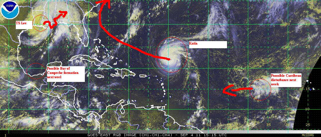
This week will see a large shift in the overall temperature patterns as a large cool high pressure area dives south from Canada into the midwest, finally delivering some cooling to Texas, the southern plains, midwest and the Ohio Valley/Great lakes region. TS Lee will remain in southern Louisiana for the next day or so, then lift out to the NE, bringing heavy rains to the Appalachian chain all the way north into New England (where it is not welcome). Lee has been a rainmaker in LA, with storm totals so far in the 10" range in the greater New Orleans area. Even extreme east Texas picked up an inch or two. Some NG and Oil production remains shut-down today but should gradually come back on line late Monday and Tuesday. Hurricane Katia surprised the Hurricane center overnight by intensifying into a small but potent category 2 Hurricane. Most models contine to keep its trajectory offshore but each run has shown a tendancy to drift east and this put the US east coast, from the outer banks of N. Carolina to New England, at some small but tangible risk later this week. Global models show anomalously warm conditions developing over the US west by mid week (finally Summer for the PAC NW) and heat re-developing over Texas, the southern Plains and the lower Mississippi valley by next weekend. The Tropics should remain active with an elevated risk of a Bay of Campeche tropical storm and a Caribbean storm developing by next weekend and into the week of September 11-18.