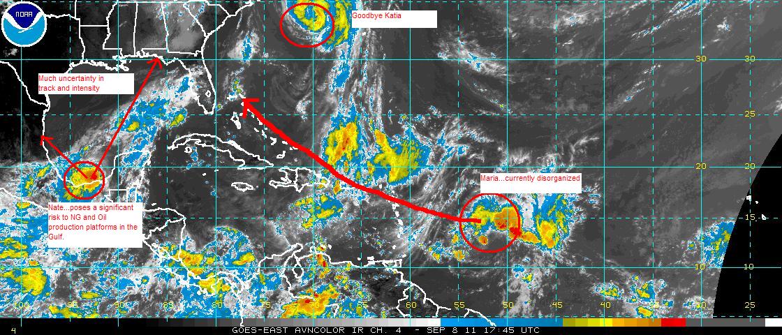
Tropical Storm Nate continues to gradually spin up in the southern Bay of Campeche today. The current suite of forecast models now tend to track Nate very slowly to the north with slow intensification to category 1 hurricane status by Saturday morning. This is the consensus track although landfall guesses at this point range from just north of Veracruz to a little east of New Orleans. The problem with Nate is that steering currents in the atmposphere now and are and are forecast to remain very weak, thus Nate the Hurricane could hang around the producing areas for several days, sharply curtailing production of oil and NG starting this weekend and extending into late next week. Nate is unlikely to make a Texas landfall, and could excerbate the fire problem as its winds and circulation extend into south texas through the weekend and into next week with little or no precipitation.
Tropical storm Maria is forecast to remain weak and disorganized until it gets near Puerto Rico early Sunday where it shoud start to consolidate a little. Chances of a US landfall are lower than 25% at this pont but the weaker it remains the further west it will get. Much of its evental track near the US depends on how strong Nate gets in the Gulf - the bigger the Nate, the further east Maria goes.
Hurricane Katia will be swept this weekend into the north atlantic and poses a serious risk to Ireland and the UK on Sunday/Monday for heavy rain and damaging winds.
Incidentally, the remains of TS Lee have brought significant and flooding rains to much of the shale gas producing areas of Pennsylvania and NY, but i have no idea what effect on production that may have through the next several days.