For the third week of Feb, according to the North American forecast ensemble, its a mixed bag over the lower 48 with above normal temperatures expected roughly over the eastern 1/2 of the country (except for New England and Fl which are forecast to remain near normal) and near normal over the west (with the exception of most of UT and central CA which should be milder than normal. The main US forecast model ensemble, the GFS, disagreees, with a forecast of below normal over the west and near normal over the east except for the NE where its forecast is for above normal conditions.
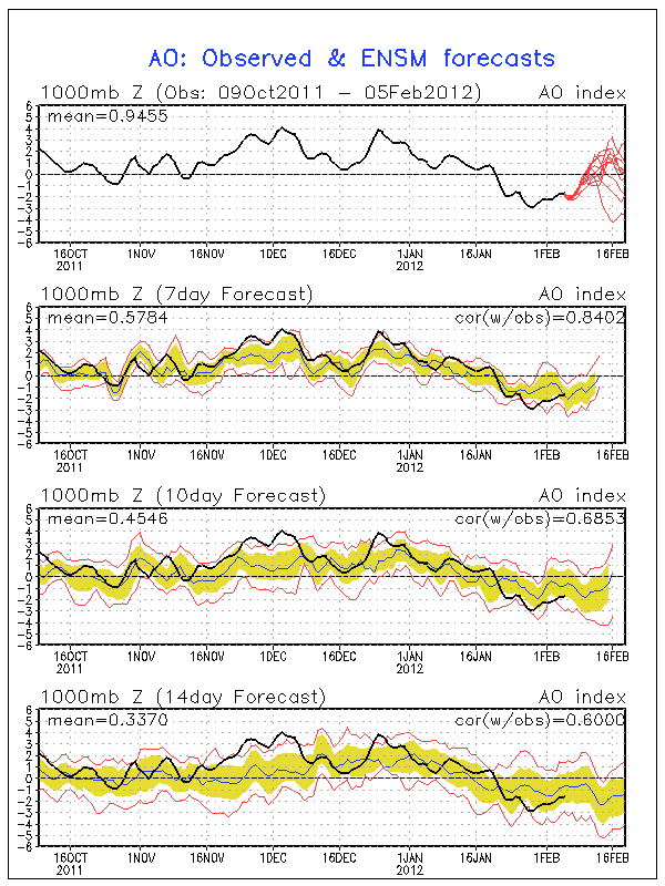
Its not surprising to have this kind of uncertainty in forecasts right now. The diagram shows the history and forecast of the AO- the Artic Oscillation. Its one broad measure of the circulation around the north pole. All things being equal, an negative AO generally means deep cold air is building over the polar region and given the right push, it will head south, meaning that the central and eastern US is due for a significant cold period shortly. This is reflected in the GFS forecast but not so much in the NAEFS. The push will come if a strong stationary low develops over the Hudson's Bay area of northern Canada.
This week will start cool over the NE and the central plains (due to the weekend's big snowstorm) but generally mild elsewhere. Colder air will push south mid-week east of the rockies and then moderate a bit before a second surge moves south toward the end of the week. West of the rockies it should remain mild, protected by a strong upper ridge. This should be a big week for NG use over most of the country, perhaps the biggest of the year. Those figures won't come out until a week from this thursday, of course.